

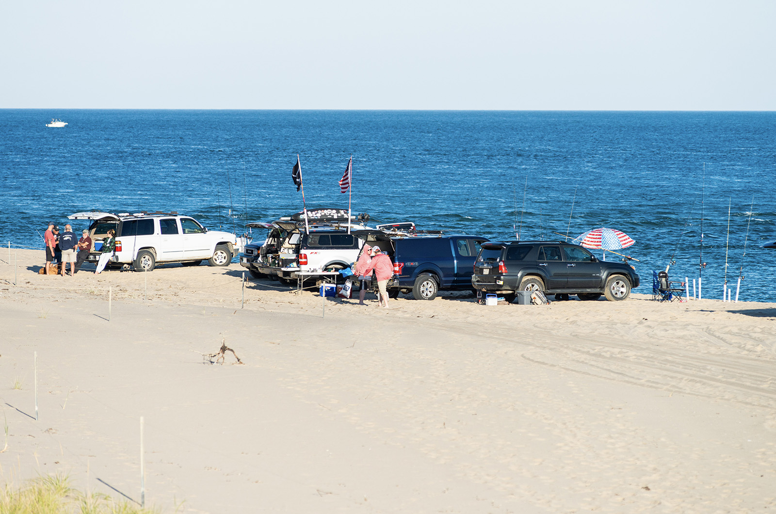
The Edgartown conservation commission Wednesday voted to allow no more than 200 vehicles at a time on the Trustees’ Leland and Wasque parcels, and no more than 30 on the Cape Pogue trails.
After more than six months of hearings and nearly 200 comments from members of the public, the new rules for driving out on the sands of Chappaquiddick have been set.
The Edgartown conservation commission Wednesday approved new limits that cap the number of vehicles The Trustees of Reservations can allow on its 16 miles of trails on the small island. The new regulations allow no more than 200 vehicles at a time on the Trustees’ Leland and Wasque parcels, and no more than 30 on the Cape Pogue trails.
The limits have been contested by the Trustees, Chappaquiddick residents and fishermen from all angles. The Trustees originally asked for 300 vehicles across all of the properties, landowners have said those limits are too high — potentially threatening the health of the beaches — and fishermen requested historical access to be preserved.

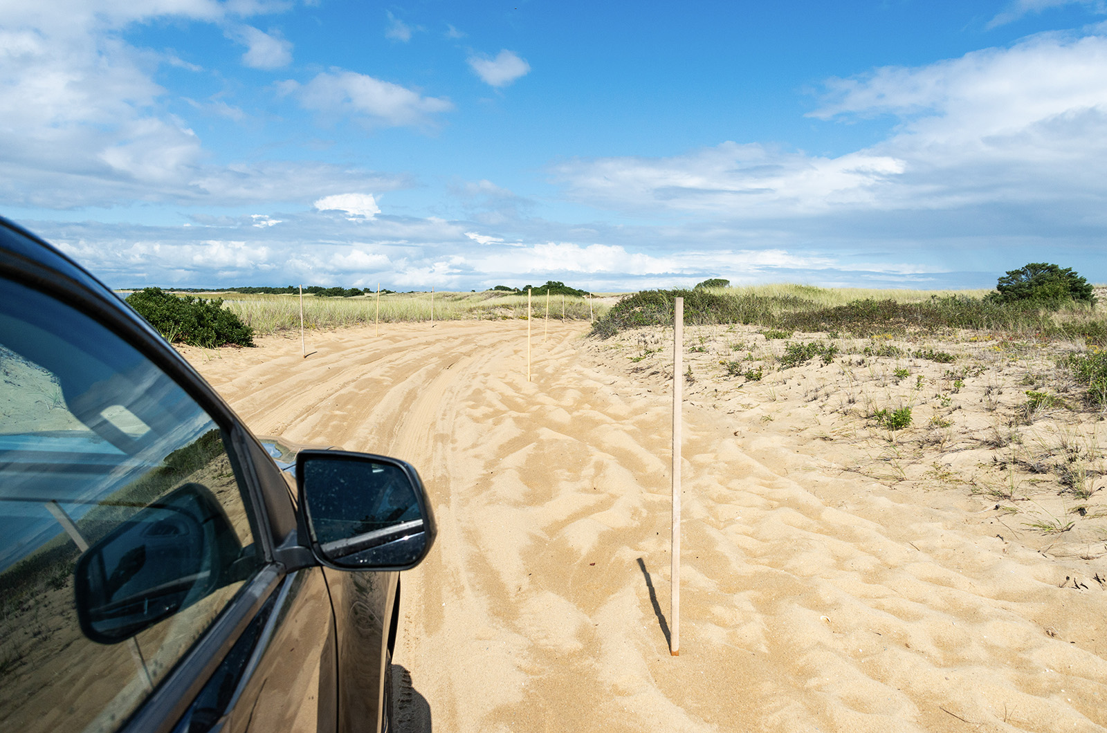
Oversand vehicle are not allowed passed the Cape Pogue lighthouse.
Oversand vehicle are not allowed passed the Cape Pogue lighthouse.
The conservation commission’s decision of 200 vehicles could be appealed by the Trustees, or a number of other parties, but the new rules give the public an idea of what it will be like to get out to Chappy’s sandy barrier beaches with Memorial Day only a week away.
For the Martha’s Vineyard Striped Bass and Bluefish Derby, the vote came as a relief.
“It’s great to see,” said Phil Horton, chair of the derby committee and a longtime Chappy fisherman. “It represents such a big part of the available beach to the derby anglers.”
The issue has been divisive and the unanimous vote from the commission came on the 10th meeting about the management of the oversand vehicle trails popular with beachgoers.
Last week, Trustees’ CEO Katie Theoharides claimed the conservation commission limits were designed to appease Chappaquiddick homeowners who have long contended that the Trustees have mismanaged the beaches. She also raised the possibility of asking the state Department of Environmental Protection to look over the conditions to possibly issue superseding regulations.
Several conservation commission members started Wednesday’s meetings by offering rebuttals to Ms. Theoharides. Member Geoff Kontje said there’s been a lot of concerns from the public about vehicle access to the beaches, largely due to the confrontations between the Trustees and Cape Pogue landowners. He attributed the issue to high turnover within the Trustees.
“There’s been no continuity on the part of the [Trustees],” he said. “Personnel have changed over and over again and this has led to a lack of familiarity, which leads to misunderstanding, friction, misinterpretations and in the end, outright conflict.”
The Trustees are currently being sued over Cape Pogue access by Cape Pogue residents, and Mr. Kontje hoped that the tempers could simmer down to keep things running smoothly.
“Please don’t be too eager to rush this into court,” he said to the Trustees Wednesday. “And for the owners out on Cape Pogue, I’d like to say please exercise some tolerance and patience and let this run.”
Mr. Kontje also slammed Ms. Theoharides opinion piece published in the Gazette last week that lay blame on Cape Pogue homeowners who have said the new limits are too high.
“I have to say that letter was a cheap shot,” he said. “It was incorrect, inaccurate, it was inflammatory and you should be ashamed.”
In addition to the vehicle caps, the new limits from the conservation commission require monthly reports from the Trustees on vehicle counts, the number of staff and trail conditions. Vehicles are not allowed in the area known as the swimming beach except during the Martha’s Vineyard Striped Bass and Bluefish Derby and off-season, and signs are to be placed at the Chappy ferry when capacity at the Trustees properties have been reached.

There have been concerns about how the beaches could be affected by oversand vehicles.
There have been concerns about how the beaches could be affected by oversand vehicles.
Wasque will only be accessible from Norton Point.
The conservation commission also agreed to halt oversand vehicle traffic past the Cape Pogue lighthouse, cutting off vehicle access to the sandy spit at the end of Cape Pogue known as the Gut.
Mr. Kontje said the limit was based on the significant beach loss in the area of the Gut, but the commission could consider allowing future access.
“The applicant would need to file a [notice of intent] and it would be absolutely necessary that a professional survey be done with current conditions from Cape Pogue to the Gut,” he said. “The current application relied on outdated aerials and did not include an actual survey, making assessing these conditions impossible.”
Trustees Islands portfolio director Darci Schofield thanked the commission for bringing the long process to the end and said it was unfortunate that the issue had become so contentious, considering everyone largely had the same goal of enjoying and protecting the exceptional island.
“I hope in the future that we can all do better and we can all strive to do better, to work together to make this goal happen for our community, for these places that we all love,” she said.
Trustees attorney Dylan Sanders echoed Ms. Schofield, saying the concerns from the commission have been heard, even though the organization may not necessarily agree with them.
“We take them to heart and we will continue to work on the issues that you identified,” he said.
The conservation commission also allowed the current rules for the Trustees to continue in case there is an appeal, a critical measure for some beachgoers who worried access would be cut off if an appeal came about.
Trustees spokesperson Mary Dettloff Thursday said the Trustees will complete a thorough analysis of the conditions from the conservation commission but she declined to comment until that process is completed.
Comments
I hope the Trustees appeal
James ChappyI hope the Trustees appeal the decision. The OSV limits are too low and the restrictions are inconsistent with the state beach management guidelines. The Trustees should promote public access, not protect the interest of private property owners who seek to create a private playground.
Commissioner Kontje lives on
OSV UserCommissioner Kontje lives on the road leading to the OSV access point for Cape Poge and Leland. He should have recused himself from the decision because he has a direct interest in seeing OSV traffic to Cape Poge and Leland decrease.
Is there going to be some
tom BostonIs there going to be some sort of webpage where users can monitor how many cars are currently using the beaches? It can be a decent amount of time to get from wherever all the way to Dikes bridge, especially if the Chappy ferry has an hour wait. I'd hate to spend an hour an a half or so getting there and being told no more entries. And then do cars just hover around the parking lot in a queue to wait for other cars to drive off so they can drive on?
The Conservation Commission
Elly H. EdgartownThe Conservation Commission is tasked with approving NOIs that comply with the Wetlands Protection Act. In this case, they applied conditions to the NOI not required under the Wetlands Protection Act for the sole purpose of appeasing the private interests of a few select abutters. This is a sad day for public access and a sad day for those that expect government to apply the law evenhandedly and consistently (no such OSV limits apply to Norton Point).
Do OSVs improve the the
Albert GosnoldDo OSVs improve the the overall quality of the beach, for all?
What did fisherman do before OSVs?
People really should be
John ChilmarkPeople really should be outraged by this… a few people want to keep this for themselves. Where are leaders? Select board? We all taxes… not just a few…. So unfair and wrong.
Kids families now want have the opportunity.
So Sad
Open the beaches in Chilmark
edg taxpayer edgOpen the beaches in Chilmark to the public. "..a few people want to keep this for themselves'... be consistent
It’s surreal to experience
Astonished EdgIt’s surreal to experience such opposition by the - community - to this proposal to see Con Comm effectively choose their own path on the matter. I thought we as Edgartown, let alone island residents had a voice through our elected leaders? When did our opinions go to the wayside of a staunch committee member like Mr. Kontje. I find it unfitting for an elected official to chastising “shame” on their right to voice opinion. This 2 year saga could have been resolved with in-person community meetings and yet here we are dealt a sad exercise in failed local politics and dysfunction on all parties. So as a TTOR member and Edgartown resident no, Mr. Kontje, you should be ashamed.
Crazy - just another example
Free Markets EdgartownCrazy - just another example of overreach and disagreement as sport and past-time. These are public spaces and should not be limited unnecessarily. If you want a private island, perhaps look here https://www.privateislandsonline.com/search?availability=sale. Otherwise, be neighborly and come join us ALL of us on the beach!
Norton Point has a OSV limit,
Clarification EdgartownNorton Point has a OSV limit, it's documented in their beach management plan which is why it didn't need to be in the conditions. From page 24: "Utilizing formulas from the 1994 Barrier Beach Guidelines, Norton Point’s maximum capacity of vehicles parked perpendicular to the beach is calculated to be 360 vehicles. In 2022 TTOR recorded a maximum of 240 vehicles in one day."
The Norton Point OSV limit is
JamesThe Norton Point OSV limit is much higher than the Cape Poge/Leland OSV limit per area of beach. The Norton Point limit is simply the limit in the state beach management guidelines. The Cape Poge/Leland limit is much, much lower than what would be allowed under the state guidelines.
Yes and no. The formula in
Clarification EdgartownYes and no. The formula in the guidelines leaves the linear ft per vehicle as X. A quick Google Earth measurement shows Leland to be 7500' (+/-) and Norton to be 12,000' (+/-) when you plug those lengths and capacities in then Norton is 33' per vehicle and Leland is 37'. Too close to be upset about really. Also, it doesn't even factor in Wasque so there really isn't an outrageous discrepancy.
The beach is conserved for
Charles Hodge EdgartownThe beach is conserved for all citizens to enjoy. Putting on limits of cars allowed is merely pandering to the rich who, in a a fit of self-serving entitlement, want to own this public beach.
YIPES!
Wake Up People! BostonYIPES!
200 cars per day is 6,000 cars per month X 2 ways or 12,000 OSV per month trips chewing up the delicate endangered beaches. Why is this so hard for people to understand? The powers that be need to stop all non resident OSVs immediately until an actual professional (Army Corps of Engineers) study has been completed to determine how all of this traffic is damaging this delicate fragile ECO System.
This reminds me of the famous scene in "Jaws" where the town mayor refused to shut down the swimming beaches because of how it would effect the bottom line of businesses during the lucrative summer season, even though there was clear evidence of a giant shark eating their kids!
Wake up people! Once the beach is gone, no one will put it back!
The damage is from winter
Trudy Highfield Edg.The damage is from winter storms not OSVs. Placing the blame on OSVs is unfair and misguided. Moreover, if OSVs are causing damage, then both resident and non-resident OSVs should be banned. The residents are residents of their respective small property parcels (which can be accessed by boat) not the entire beach. And if residents of one end of Cape Poge can access the beach by OSV, why not residents of the other end (Edgartown/Chappy).
Seems reasonable if max
Danny East ChopSeems reasonable if max number of cars back in 2022 was 240.
Allowing 200+30 OSV’s at once after how many parking spots the ocean took away this winter seems like a fair-to-generous compromise to me.
Except it’s only 30 on Cape
Allen T. MVYExcept it’s only 30 on Cape Pouge and 0 beyond the lighthouse, so those numbers are much less.
If I understand the Gazette
Another OSV User EdgartownIf I understand the Gazette article. Only way to get to Wasque is through Norton Point.
What happens is Mother Nature creates another breach along the way . No access to Wasque?
So what's the penalty if I
Jim 4x4So what's the penalty if I drive beyond the lighthouse? Am I trespassing? Will I be arrested?
With such blatant self
Zack Baird EdgartownWith such blatant self interest while overstepping in this plan, Mr. Kontje should be removed from his role. Terrible decisions by this committee, after many delays because they wouldn't show up to meetings.
having the facts is always
facts of the matter Edgartownhaving the facts is always helpful in the face of anger and distrust and unfortunately misinformantion from the responsible party...ttor. The meetings were delayed not because they were not able to attend a meeting, which only happened once, but because TTOR made so many errors in their application, leaving out entire parcels of the beach and other fatal errors that would have resulted in lack of access to several key parcels of beach, which under the approval are now accessible. TTOR did not discover these errors on their oww, that was the real reason why months were added on to a process that has lasted for years now from the first filing abandoned by TTOR after fatal errors were admitted and TTOR was given another chance to get it right.
This may be a good start but
Artie EdgThis may be a good start but we need to get back to historical access. Please remove the low limits on Cape Poge, open up OSV access to the Gut and Wasque, and allow dogs on Cape Poge and East Beach year round. Inch by inch they are taking away historical access. We need to keep up the fight.
WINNERS - The Cape Poge
Ron Domurat EdgartownWINNERS - The Cape Poge homeowners particularly the fortunate few who are privileged enough to own property beyond the Cape Poge lighthouse. None are permanent residents and many own second homes elsewhere in Edgartown. They now have their own private enclave that includes the THREAT of a locked gate if OSV users ignore signs and travel beyond the lighthouse! A locked gate on Cape Poge???
LOSERS – Islanders and visitors to Martha’s Vineyard who for decades have frequented this beautifully remote area via OSV to fish, shellfish, or simply relax by the water.
Shell fishermen, particularly Edgartown recreational scallop fishermen who lose OSV access to this prUime area!
Derby anglers who lose OSV access to the Cape Poge Elbow and the Gut, favorite down island spots to fish for bluefish, false albacore, and bonito. All three of the eligible Derby species.
The Edgartown Conservation Commissioners who ignored pleas by the public, including many Edgartown and other island residents, for a continuation of OSV access beyond the lighthouse, and who bought into the land grab by the Cape Poge property owners under the guise of conservation. They got this one wrong and hundreds are affected!
I could not agree more Ron…I
Jack EdgartownI could not agree more Ron…I am so disappointed in our leaders. Where are they?? Select board etc..,
The worse thing for the
Johnny R.L. EdgartownThe worse thing for the environment of Cape Poge Bay are the private houses (with septic systems and moorings) surrounding the bay. If the conservation commission is serious about protecting the bay, and not creating a private playground for those houses, then future discussions should include the use of eminent domain to return Cape Poge to a natural state. It would be wonderful if the land surrounding the Cape Poge Lighthouse was all natural with no human habitation.
It’s open to everyone, but
Ted ChappyIt’s open to everyone, but not your truck. National forests have similar regs for hunting - open to all hunters, but not the ones who need vehicles to get around.
Sure thing Ted. I don't own a
tom BostonSure thing Ted. I don't own a boat so I'll walk out to the gut from the lighthouse to fish and then haul my catch back to my vehicle. And if the family wants to come we will haul all the beach gear in/out by foot.
Inch by inch, nature is
Eva EdgartownInch by inch, nature is taking the beaches out to sea. More of us with bigger and Heavier SUVs drive on the beach. Perhaps we can limit the vehicle weight to the historical access numbers too. Historical access is just that, access during a time in past history when conditions and users were different from what they are today. I'd like to see the 'road to the gut' professionally surveyed, and overlaid on a current aerial map of the area. That would be useful, true information for all concerned. Your can do this with Wasque now. Wasque is a fraction of what it was 20 and 30 years ago, when we freely drove onto and around it. All the changes added together mean different conditions today. It's not rocket science.
Add new comment