

A strong storm with winds of 50 miles per hour hit the Vineyard Tuesday night, causing erosion, destructive washovers and scattered power outages throughout the Island.
A strong storm with winds of 50 miles per hour hit the Vineyard Tuesday night, causing erosion, destructive washovers and scattered power outages throughout the Island.

A culvert along Atlantic Drive in Edgartown failed, closing the road indefinitely.
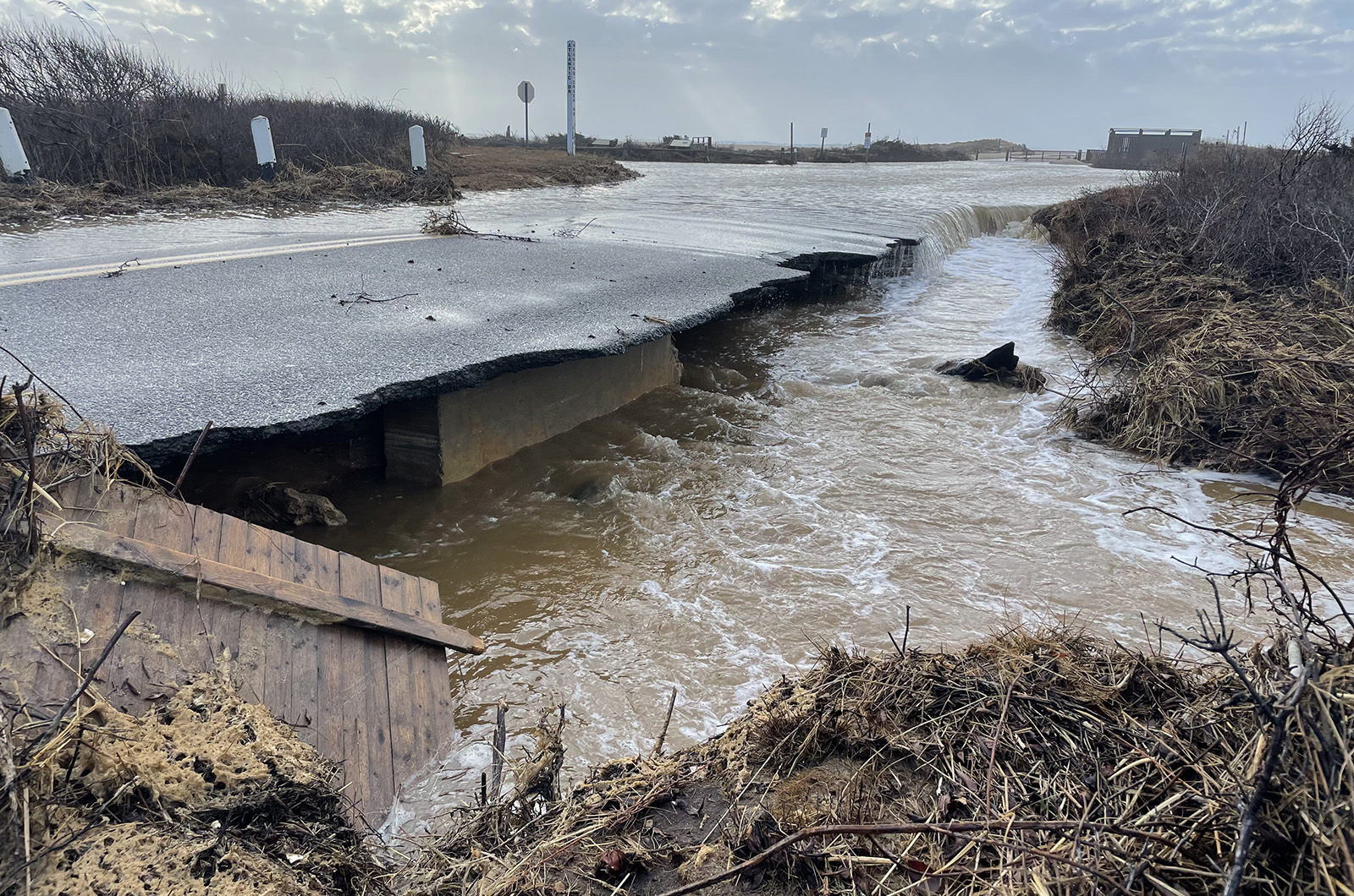
A culvert along Atlantic Drive in Edgartown failed, closing the road indefinitely.
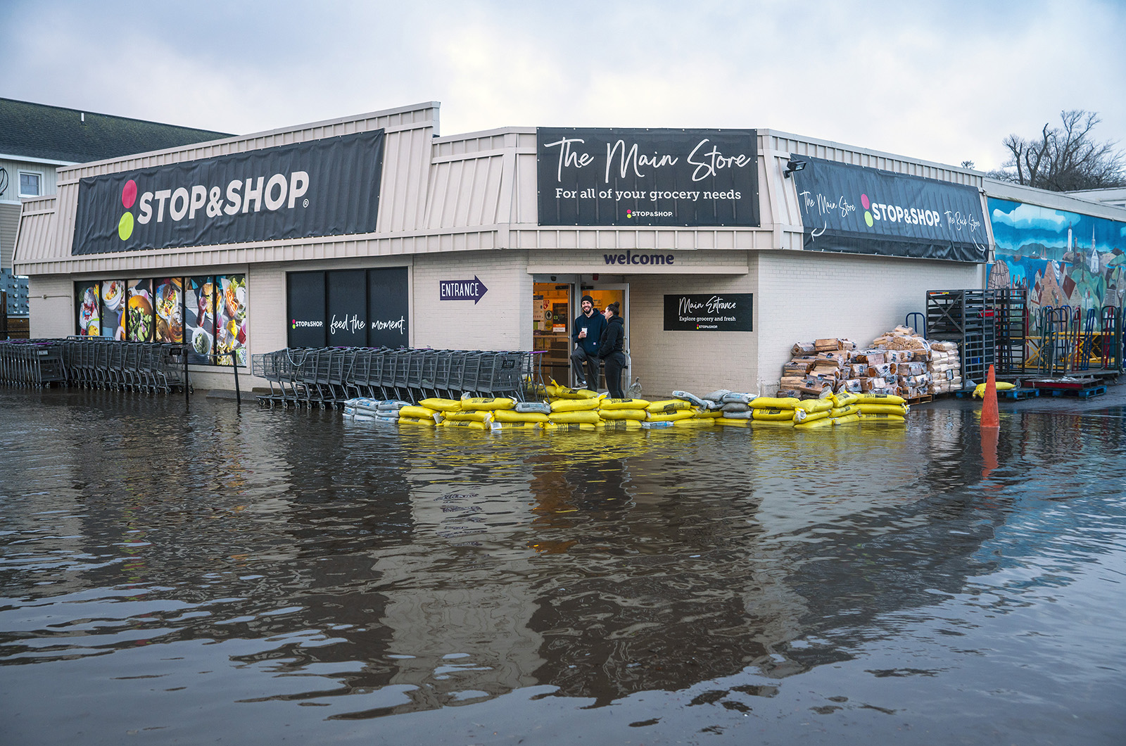
More than a dozen Steamship ferries were canceled, Five Corners in Vineyard Haven was underwater and south shore beaches continued to be pounded by waves on Wednesday.
The storm’s power was on full display in Edgartown, where the ocean washed over South Beach, causing a culvert on Atlantic Drive to fail. About a fifth of the waterfront road had torn away, only a couple of weeks after a sinkhole had opened up there in a December storm.
The Chappy Ferry had also stopped running Wednesday morning as much of the downtown waterfront was inundated with water.
With water still lapping over Atlantic Drive, Edgartown town administrator James Hagerty said the road would remain closed until a full assessment could be done. Cleanup work would likely happen after Saturday, when the Island is expected to see more rain and southeast winds up to 55 miles per hour.
“We’ll assess it after it dries up and look at what needs to be done to make it safe,” Mr. Hagerty said.

Waves as high as 18 feet were recorded about two miles off the Island.
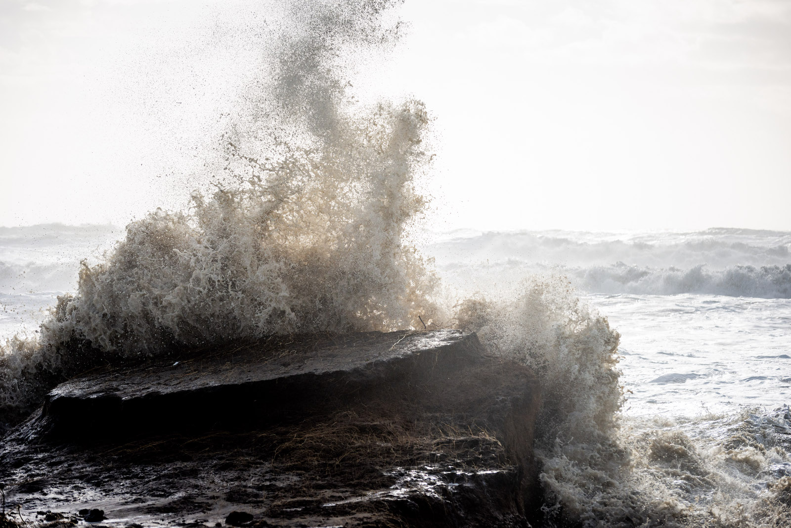
Waves as high as 18 feet were recorded about two miles off the Island.
The storm, which was predicted to have winds between 30 and 40 miles per hour with gusts up to 60 miles per hour, dumped about three inches of rain. The extra water and high waves added to the woes in Vineyard Haven, where even minor storms can make it impossible to navigate the waterfront.
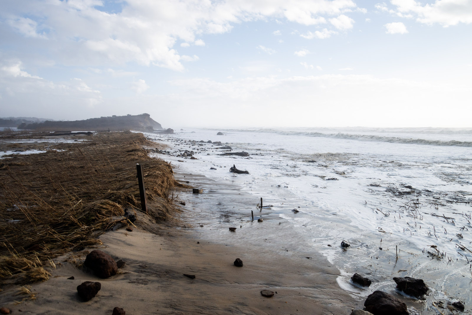
This storm was similar to the Dec. 18 storm that walloped the Island’s south shore. It, too, came from the south, creating breaches and erosion on several beaches, including Lucy Vincent and Squibnocket beaches in Chilmark.
“[This is] worse than [Hurricane] Sandy was,” Chilmark select board member James Malkin said while walking along Lucy Vincent Beach Wednesday morning. In late October 2012, Hurricane Sandy caused extensive erosion on the south shore.

Waves were crashing onto Lucy Vincent and washing over into the parking lot.
Waves were crashing onto Lucy Vincent and washing over into the parking lot.
On Wednesday, the ocean had breached into the nearby pond and waves were starting to make their way into the beach parking lot. Curious beachgoers waded through the water to see the damage at the beach, which had already lost about 13 feet of sand last month.
“You can see the chunks falling off,” said Joan Malkin, chair of the Martha’s Vineyard Commission, while touring the damage with her husband.
Every wave coming in was going into the pond, she added.

Vehicles struggle to make it through the flooded Five Corners.

Vehicles struggle to make it through the flooded Five Corners.
The Trustees of Reservations also reported significant erosion at its properties. Wasque on Chappaquiddick lost a large amount of coastal bluffs, and the dunes at Long Point in West Tisbury were flattened after getting battered in the previous storm.
“We saw flooding in the sand plain grasslands at Long Point at high tide, which is concerning to us because it is a fragile ecosystem,” said Mary Dettloff, a Trustees spokesperson.
The waves along the south shore were tall, though slightly smaller than during the previous storm. The Woods Hole Oceanographic Institution’s Martha’s Vineyard Coastal Observatory off South Beach recorded waves of about 18 feet shortly after 12:30 a.m. Wednesday. The Dec. 18 storm had waves of about 25 feet.
The observatory is about two miles off South Beach in about 50 feet of water. These waves were among the highest in recent memory, said Anthony Kirincich, a senior scientist with WHOI who oversees the coastal observatory.
“It had not been at 30 feet any time in the last decade,” he said.
Officials have said that southerly storms can be more destructive on the Vineyard than the typical winter northeaster, as the Island has no buffer on its south shore.
“If the winds are out of the south, there’s a lot more ocean for the waves to build,” Mr. Kirincich said.
Comments
This is climate change!
Jean EdgartownThis is climate change! Thankfully we have people like John Kerry and Al Gore educating us in this. I encourage people look at Al Gore’s podcast on Global warming. It’s real.
Jean, exactly it’s climate
Josh West TisburyJean, exactly it’s climate change. People want to drive around in these ridiculous huge SUV’s and and have solar panels on there homes. People we need to think about the emissions!’
Um, solar panels on the homes
Carol formerly ChilmarkUm, solar panels on the homes is an excellent way to fight climate change.
Driving down into OB along
Chip Coblyn OBDriving down into OB along the harbor was an adventure, as the harbor extended across the road drowning the sidewalks fronting the Summercamp Hotel.
Martha's Vioeyard is a pile
Peter Thalheim Stamford, CTMartha's Vioeyard is a pile of sand left by the last Ice Age in the Atlantic Ocean and has over 3,000 miles of open ocean to Europe. Charts from the 1800s consistently show breaches in Norton Point Beach into Katama Bay. Rarely does a chart show a sand bridge between the main island and Chappy. Let us not needlessly dirty our environment, but climate change is not why waves wash MV sand into the ocean. It is a natural cycle. Long Island Sound was a fresh water body of water after the last Ice Age until rising sea levels and erosion allowed the salty ocean to mingle with its fresh water. Now it is an estuary.
Has anyone spoken to the
Dana Hodsdon VhHas anyone spoken to the state or brains of MV about the use of artificial reefs by sinking scrap ships,or installing tetrapods to create wave breaks on the south shore, to abate the erosion?
Add new comment