

<p>The storm that slammed the Island in early November cancelled ferry trips and eroded beaches on Chappaquiddick. It also unearthed a mystery.</p><p>Pieces of what appears to be a 19th-century shipwreck were exposed on East Beach at Cape Pogue.</p>
The storm that slammed the Island in early November cancelled ferry trips and eroded beaches on Chappaquiddick. It also unearthed a mystery.
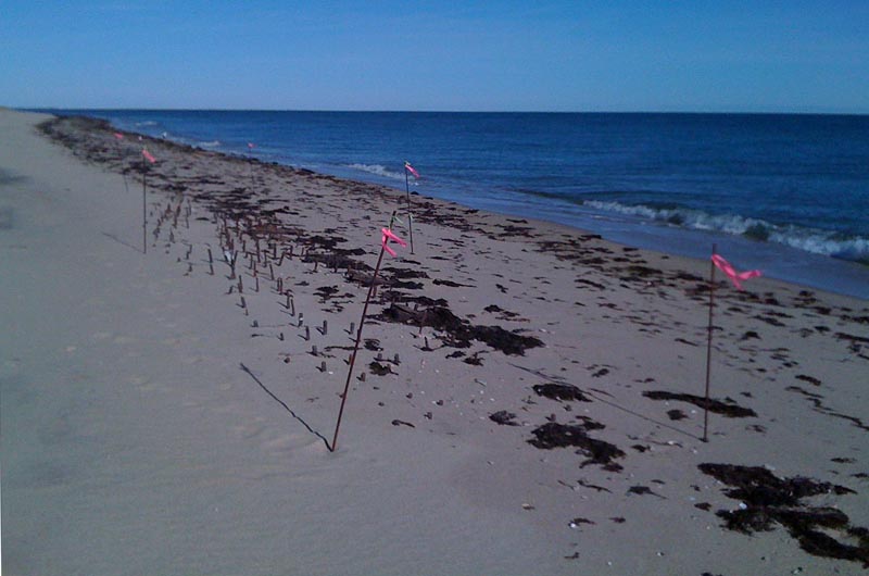
Pieces of what appears to be a 19th-century shipwreck were exposed on East Beach at Cape Pogue, said Chris Kennedy, Vineyard superintendent for The Trustees of Reservations.
Iron pegs that once attached wood planks to the ribs of the wooden ship are visible in neat rows on the beach opposite Shear Pen Pond, Mr. Kennedy said. They were unearthed by the northeaster that hit the beach the first weekend of November.
This is not the first time the shipwreck has been exposed, Mr. Kennedy said. “I guess I’ve seen it maybe five times in the last 25 years. It obviously has been there for a long, long time.
“I’ve never really heard just what wreck it might be,” Mr. Kennedy said.
The last time the ship was unearthed was during Hurricane Sandy in 2012.
A few years ago an Army helicopter flew over the Island to look for munitions buried on Chappaquiddick beaches, Mr. Kennedy recalled. “They found this weird anomaly,” he said: a perfectly shaped group of hundreds of little bombs. It turned out to be the iron spikes from the shipwreck.
Mr. Kennedy said that the remains are clearly from a wooden ship, because wooden timbers can be found beneath the iron pegs. The iron pegs and the wooden construction help hint at the date the ship was built.
Mr. Kennedy said that southwestern winds will bring sand back to the beach and eventually the pieces of the shipwreck will be buried again by a foot or two of sand. “By next summer you wouldn’t even know it’s there,” he said, and people will set up on the beach with blankets. Little do they know, he said, “they’re sitting right on top of an old, old shipwreck.”
The Trustees announced the discovery on Facebook and invited people to come see the wreck, but asked visitors not to disturb the site.
Arnold Carr, a Vineyard native, marine biologist and shipwreck expert, said at first early this week that he hadn’t heard about the discovery. He said the size of the timbers and the construction of the ship could be clues as to what type of ship it was.
“It could be anybody’s bet,” he said. His first guess upon hearing about a shipwreck on Chappaquiddick was the Mertie B. Crowley, a six-masted schooner that sank off Wasque in 1910. But the location of the wreck ruled out the Mertie B., Mr. Carr said.
After getting the coordinates of the shipwreck and doing some research, Mr. Carr narrowed the wreck down to a few likely candidates: the schooner Sarah Lewis, which sank in March 1853, the schooner Silver Bell, which sank in 1856, and the brig Empire, which sank in 1856. Mr. Carr said his guesswork was based on estimated position.
He cautioned that locations are approximate because they are based on the best available historic data available and said there are other wrecks in the general area that are unaccounted for.
Mr. Carr said there are also wrecks offshore, such as the Christiana, which wrecked on Hawes Shoal in 1866. But only the bilge of the Christiana remains, Mr. Carr said, and the rest of the hull is gone and could have washed ashore.
The early November northeaster did more than just expose a mysterious shipwreck. Elsewhere on Chappaquiddick, beaches were closed to over-sand vehicles last week because of erosion on beaches, though some beaches have now reopened.
With wind gusts reaching up to 60 miles per hour, Mr. Kennedy said one of three steel cables connected to the Cape Pogue Lighthouse snapped. “It’s when you have a storm like this that you realize that lighthouse is fairly lightweight and it does sway back and forth,” Mr. Kennedy said. He said the cable would be replaced.
Comments
Ahhh yes,'tis most likely the
Salty Edgartown HarborAhhh yes,'tis most likely the ol' Mertie B Crowley...http://vineyardgazette.com/news/2010/01/21/century-later-epic-sea-rescu…
I remember, as a child, going
janet Brown Jussel chappyI remember, as a child, going out with Foster Silva in his green truck,watching for that ship wreck
We never knew the name of the wreck,it as just one of the many special occurrences of going out with that wonderful friend.
I question whether this is a
Alton Day Stone Sterling, MA and Quammox Road, ChappaquiddickI question whether this is a ship wreck only for the following reason:
Presumably East Beach has been eroding in the landward direction - westward toward Poucha Pond - with the width of the barrier continually decreasing and/or the beach migrating westward toward Chappy. If so then the land where the "wreck" is located has been beach for a long time, possible for 10,000 years, with the shoreline 150 to 200 years ago much further outward to the east. So how did the wreck end up 1/4 mile or more up on the beach, if it foundered on the outer shoals off East Beach? Perhaps East Beach was not there 150 years ago and the ship foundered directly off Chappy. Then the beach developed and covered the wreck?
To revise my earlier comment.
Alton Day Stone Sterling, MA and Quammox Road, ChappaquiddickTo revise my earlier comment. The wreck is not a wreck at the location of sinking, it most likely a piece of a wreck that washed ashore and subsequently was buried at the waters edge. 150+/- years ago one of aforementioned schooners ran aground on the shoals off of Cape Pogue/East Beach. The ship then broke up in the surf (as they often did) and a substantial piece, perhaps half the hull eventually washed ashore and fetched up on East Beach. Short term local perturbances - e.g. storm swells, current shifts & gyres - resulted in burying the piece under the sand. Similar events periodically uncovered and then reburied the wreckage. Thus, it has been occasionally observed over the years as it becomes unburied and then reburied. The rate of beach recession along the section of East Beach south of Cape Pogue Point down to say Arudas Point appears to be rather less than along South Beach. 35 years ago the old radiator from the light keepers house was at the very base of the sand cliff. Now its out in the water, but not to far out, maybe 20-30 feet (?) from the base of the cliff. Due to the overall slow movement of the beach westward along this section, its possible for the piece of the wreck to remain buried for many years and then be uncovered. Eventually it will be uncovered permanently and we will have to wade or swim to see it. Even along South Beach south of Wasque Point, that has been receding northward at a very rapid rate, events will occasionally throw up a substantial, though usually temporary, new sand deposit along the beach or out in the channel which eventually gets washed away. Skiffs and Fischers Islands off Wasque are sand banks of this type. The sand pokes its head up above the water and becomes an island for a brief bit and then disappears. And the beach keeps moving northward.
Add new comment