
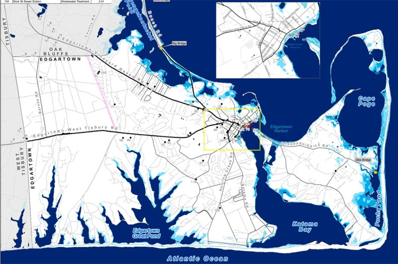

At high tide on a sunny day in the year 2100, a visit to Five Corners in Vineyard Haven could mean a swim with the fishes. New maps created by the Martha's Vineyard Commission project a changing seascape.
At high tide on a sunny day in the year 2100, a visit to Five Corners in Vineyard Haven could mean a swim with the fishes. A man strolling along Dock street in Edgartown might find himself chest-deep in water, and a large portion of the Inkwell Beach in Oak Bluffs could be swallowed by the sea.
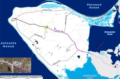
These likely victims of sea level rise are highlighted on a new map created by the Martha’s Vineyard Commission that shows possible changes in the Vineyard seascape for future generations.
According to the projection used for this set of maps, the level of the ocean around the Island could rise one and a half feet by 2050 and five feet by 2100, surpassing estimates for some other parts of the world.
For down-Island towns, rising seas threaten homes, businesses and critical public infrastructure over the long term.

Maps could lead to future zoning changes for areas thought to be at risk.
Maps could lead to future zoning changes for areas thought to be at risk.
While sea level rise worldwide has averaged two millimeters per year between 1971 and 2010, according to the International Panel on Climate Change, sea level rise at Nantucket averaged 3.94 millimeters per year in a similar period of time, according to a study performed by NOAA.
Maps showing potential sea level rise are part of a broader project at the Martha’s Vineyard Commission to plan for natural disasters. The so-called Hazard Mitigation Plan, the second such plan the commission has produced, came out in draft form in March. Cartographer Christine Seidel and coastal planner Jo-Ann Taylor collaborated on the plan.
The Martha’s Vineyard Commission combined local subsidence levels with some of the most conservative estimates for sea level rise to present a likely scenario useful to planners.
Their computations show that down-Island towns are at a clear disadvantage when it comes to sea level rise. Though losses are somewhat minimal for the first part of the century, by the year 2100, an estimated $30.9 to $64.5 million of developed land in each of the down-Island towns will be threatened by sea level rise.
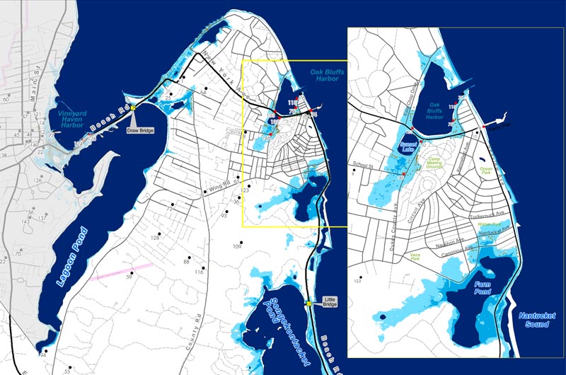
Tisbury stands to lose as much as $48.8 million in infrastructure by the end of the century, including 177 buildings and three critical facilities. In Oak Bluffs an estimated $30.9 million worth of developed land and 108 buildings are at risk. In Edgartown $64.5 million worth of property and 75 buildings are estimated to be at risk.
The up-Island towns are projected to fare better. Only three buildings in Aquinnah, for example, are threatened by significant sea level rise by the year 2100. For Chilmark, the maps show that nine buildings are threatened by sea level rise, which together have an assessed value of about $3 million.
The maps are more precise than their predecessors, but they remain educated guesses about the potential impact of sea level rise on the Vineyard, planners caution, and the models that created them are far from perfect.
The maps model the sea as a bathtub, in which the water has a uniform height throughout.
Downtown Vineyard Haven projected to lose $48 million in infrastucture by the year 2100.
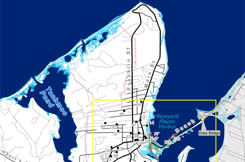
Downtown Vineyard Haven projected to lose $48 million in infrastucture by the year 2100.
In reality, sea level rise is complicated by other factors, including subsidence, or sinking, and constant changes in the geometry of the shoreline due to erosion.
“Everyone is facing the same problem,” said Mark London, executive director of the commission. “The model is not really there yet.” More accurate modeling might be available to the commission within a few years, he said.
While most available maps, including the current elevation modeling from the Federal Emergency Management Agency, involve historic data, sea level rise projections approximate the future.
“They are all backward-looking, they are all looking for trends,” Mr. London said of the FEMA and other maps. “These are trying to project more into the future.”
For the plan, the commission has also mapped the Vineyard with respect to hurricanes, northeasters and wildfires.
Wildfires, though infrequent, have wreaked havoc on large parcels of the Island in the past. The Island’s sandy soils, which drain quickly, increase the risk of a wildfire, as do the large number of decaying pines in the state forest, according to the hazard mitigation plan.
Though West Tisbury can breathe easy with respect to sea level rise, it might do well to turn its attention to wildfire hazards.
The town has 12 critical facilities located in vulnerable wildfire territory, according to the commission’s new maps.
The maps will help the commission in reviewing coastal developments, Mr. London said. They are also a planning tool for town planners and emergency management personnel.
Eventually, the maps could lead to changes in zoning for areas that are at greatest risk, Mr. London said. “If an emergency arises, and someone needs to be rescued, it’s going to be the volunteer fire department or police department who has to go out there and risk their lives,” he said.
In the future, people may begin moving out of risky areas or including features in the construction of their homes that protect them from natural hazards, he said.
A third audience for the maps is the Vineyard homeowner, who can look to them to find out if their neighborhood is projected to be a high-risk area. Individual homes are not easily identifiable on the maps, though some shops and houses appear denoted by a brown dot, indicating they might be affected by the disaster depicted on that map. In some cases, residents of vulnerable neighborhoods can take practical steps to protect their homes from disaster.
Aquinnah has a largely unbuilt shoreline and is considered less at risk.

Aquinnah has a largely unbuilt shoreline and is considered less at risk.
For example, homes threatened by wildfire might consider replacing traditional cedar shingling with an asphalt roof, and clearing underbrush away from the house, Ms. Seidel said.
Preparation for hurricanes and northeasters can involve similar practical measures, Mr. London said.
“Do everything you have to do to batten down your house for a storm,” he said.
The planning of new facilities can now take these maps into consideration, and make efforts to minimize the effects of a given hazard on the integrity of the structure. For example, when the new hospital was built a few years ago, it was built from brick, which has high storm resistance, Mr. London said.
Though much of the world is vulnerable to the effects of climate change, much of the Island’s economy is dependent on the port towns.
“We are particularly at risk because so much of our infrastructure is near the water, especially the downtown of the three main towns,” Mr. London said.
Fortunately, the commission had the foresight to set up a coastal district of critical planning concern to limit development right on the edge, he said. The coastal district was one of the early DCPCs created by the commission in the 1970s. “They weren’t doing it with hazard mitigation or climate change in mind, they were doing it for natural ecology, or to preserve the views, but in retrospect other places in the U.S. would have been better off had they done what the Vineyard did,” Mr. London said.
These days, people have become more aware of the risks involved in buying property vulnerable to the ocean’s fury, he said. Several homes on both Islands have had to be moved or demolished to avoid being sucked into the ocean. “I think it’s going from a very long-term, theoretical threat that can be ignored to something very real and short term,” the MVC executive director said.
The maps attempt to make natural threats relevant for Islanders, who may otherwise think of them in abstract terms.
“It’s our job to step back,” Mr. London said. “People are involved in their daily lives, and what they are going to have for supper, and which beach they are going to go to, or which job they are going to go to if they are working three jobs. It’s our job to step back a bit and to look at the bigger picture, whether it’s geographically or in terms of time. What might things be like 30 years from now, and is that really where we want to go?”
The draft Hazard Mitigation Plan and corresponding maps are available through the commission website, by searching “Hazard Mitigation Plan” in the search key at mvcommission.org.
Comments
Olivia Hull tells us in her
Steve Case Milwaukee, WIOlivia Hull tells us in her report:
"...the level of the ocean around the Island could rise one and a half feet by 2050 and five feet by 2100 ..."
And
"...sea level rise at Nantucket [between 1971 and 2010] averaged 3.94 millimeters per year"
Eighteen inches by 2050 would be a tripling of today's rate of sea level rise, and 60 inches by 2100 a quadrupling.
Satellite data for sea level kept by Colorado University's Sea Level Research Group shows us that from 1992 to 2003 the rate of sea level rise was 3.6 mm/yr and since 2003 the rate is 2.9 mm/yr.
If the rate of sea level rise has declined 0.7 mm/yr over the last 20 years one has to wonder when the current trend is going to reverse and the tripling and quadrupling of the rate of sea level rise is going to begin to happen.
Steve Case - Milwaukee, WI
Answering your question -
Carol formerly ChilmarkAnswering your question - when the tripling and quadrupling of the rate will occur - that's easy. When the West Antarctic and/or Greenland ice sheets melt, which (1) put a lot of water into the ocean that is currently on land and therefore not in the ocean (unlike floating ice sheets), and (2) present a much darker surface - the newly revealed land under the former ice sheet - that absorbs heat from the sun, rather than reflecting it as a white ice sheet does.
The New England coast is also
Dan ObThe New England coast is also sinking, which compounds the effects of a rising sea.
The following document
And the tax base?The following document indicates the financial losses from sea level rise in Tisbury in 50 years. Taking the total tax assessments of Tisbury and subtracting these properties will reduce the ability to pay down bond issues by what percentage? But this will not happen all at once. And so, the question is, how do we not only mitigate the flood damage itself, and the damage to the infrastructure, but how do we pay for mitigation and for replacing key infrastructure - and we also have to consider that many of our prime tourism resources will be affected? Not just in Tisbury, but all over the island. It appears as though this is not a problem that can be solved without very advance planning.
It's a good thing climate
Aron WTIt's a good thing climate change is a myth, right? If Bill 'Tides Go In, Tides Go Out. You Can't Explain That' O'Reilly says it, it must be true!
If we are to believe the
Hal Peters EdgartownIf we are to believe the alarmist leftists, we should see property values drastically drop over the next few years along the precious coastline properties. I'll be watching.
It's likely that a greater
thomas hodgson wtIt's likely that a greater downward pressure for shore price values might come from increased property insurance costs, as subsidized flood and storm insurance withers away. In an environment where insurance bills are increasing from 2-3K per year to 20-30K or more, owning that place on the beach becomes an expensive liability. One thing for sure is that these higher costs will drive all but the richest, or those willing to quit having insurance, from beachfront property.
Allow the building of stone
BG EdgAllow the building of stone bulkheads. Letting 'mother nature' take her course won't solve the problem. Why should the Vineyard sit back and let the sea take away valuable real estate when cities built below sea level such as New Orleans get federal money to remediate their poor planning. South Beach should have had 'beach replenishment' long ago. There used to be 100ft plus deep beach, the bunker was above ground, now its in the water. Federal money has gone to many eastern seaboard states to pump the sand back onto the beaches, but for some reason people here just watch and do nothing as the Island slowly disappears.
This report from the MV
Frank Brunelle Vineyard HavenThis report from the MV Commission spells out the consequences for 50 years into the future... http://www.mvcommission.org/doc.php/PDM%20Tisbury%20assessment%20for%20…
It's under MV Commission, Resource Center, Resource Documents, search for "sea level"
So, looking on the bright
Ted OBSo, looking on the bright side of things, the silver lining to be found in all of this is that "the Inkwell Beach in Oak Bluffs could be swallowed by the sea". Thank you for that thought - it makes climate change much more palatable.
It is admirable that the
John Englander Boca Raton, FloridaIt is admirable that the Vineyard is looking at this issue fairly early. Rising sea level is now a reality that all coastal communities must face. It can be slowed, but not stopped. It is difficult for us to accept because sea level has been quite stable for the last five thousand years. The last time it was higher than at present was 120,000 years ago, one full ice age cycle in the past, when it reached some 25 feet higher. Of course, that pre-dates human history. But rise it will. It is simple physics. The oceans have already been warmed by approximately 1.5 degrees F over the last century. As a result the glaciers, and the ice sheets on Greenland and Antarctica will get smaller raising sea level. Ice melts at 32 degrees no matter what we believe politically. It sounds like the MV Commission is looking at this very challenging issue with good common sense - typical of the Vineyard. I am glad to see that as all my childhood summers were spent on the Island. For anyone interested, additional information is on my website www.johnenglander.net or in my book, "High Tide On Main Street". In fact, the book closes with an anecdote from the Vineyard.
I hope the conservatives/Tea
obporch obI hope the conservatives/Tea Folks don.t blame our president for this,too.
The biggest problem with the
thomas hodgson wtThe biggest problem with the "bathtub" model is that it does not account for the movement of sand. This is a glaring flaw. But hard to model, as the complexities of sand transport and marsh dynamics are far more complex and are less well understood than water rising in bathtubs. As sea level rises, barrier beaches do not just sit there and get covered over, blub blub blub, by rising water. No. They retreat towards the coastline. In the future, we will still have beaches, but they will have moved. As water rises and starts to deepen over marshes, the land further inland gets wetter, and the marsh retreats into these newly-wet areas. If you have lived here for any length of time, you have seen these processes with your own eyes.
So the weathermen, who often
john in ct connecticutSo the weathermen, who often can't get tomorrow's forecast correct, have it all figured out for fifty years from now, sound about right?
Weather and climate are not
Hank MAWeather and climate are not the same. Predictions (or projections) about each are made by different experts.
Add new comment