

An effort to link adjacent properties with a hiking trail has pitted the Martha’s Vineyard Land Bank against the owners of the Outermost Inn, whose land must be crossed to access the trail.</p>
An effort to link breathtaking adjacent properties near the Gay Head cliffs with a hiking trail has pitted the Martha’s Vineyard Land Bank against the owners of the Outermost Inn, whose land must be crossed by hikers to access the trail.
The legal dispute between the land bank, which wants to use a loop trail to connect the properties, and the Taylor Realty Trust was the subject of arguments in front of the State Supreme Judicial Court on Tuesday, and featured a glimpse into a relatively obscure but critical corner of real estate law involving easements.
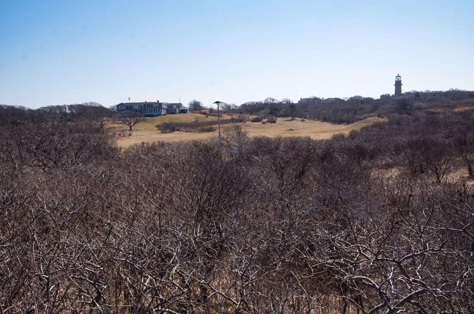
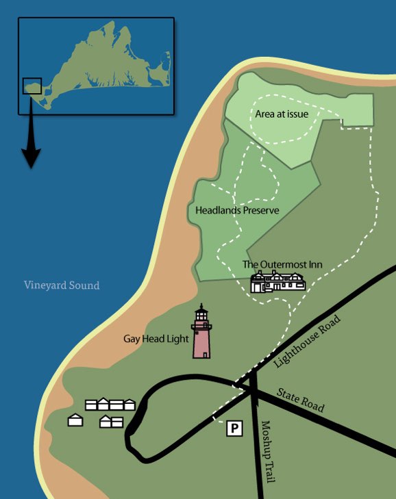
The land bank is one the Island’s largest landholders, and there is no dispute that it owns the two adjacent parcels, which are part of the 49-acre Aquinnah Headlands Preserve. The parcels are in the North Head section that opened to the public in 2011 and feature unspoiled land that rolls out to the cliffs northwest of the Aquinnah lighthouse, with views of Vineyard Sound and the Elizabeth Islands beyond.

Lawyers on both sides argued case before the State Supreme Judicial Court.
Lawyers on both sides argued case before the State Supreme Judicial Court.
But a loop trail connecting the parcels has been blocked by the legal dispute. Because those two parcels have been determined to have separate chains of title that afford separate access, those routes resemble a pair of pincers that don’t close at the top, where the parcels share a common property line.
As a result, the North Head trails now in use wander up to and back from the property boundary and out to the cliffs that once held a Coast Guard station, using a right-of-way that is not available to the other, northeasterly parcel. An attorney for Hugh C. Taylor, Jeanne S. Taylor and Brian M. Hurley, who are trustees of Taylor Realty Trust, told the justices that allowing the two parcels to be linked would violate a “bright line rule” against overloading easements that has been in place since the 19th century.
“What the land bank is proposing here is that you adopt a rule or an exception that is completely unprecedented, that is untethered from the very basic principles of easement law,” said Gordon M. Orloff, representing the Taylor trust. “The land bank is basically saying, you should throw all those out the window.”
However, in this case, the land bank’s lawyers say they do not seek the creation of a new easement, but merely a common-sense exception that would have little or no adverse impact and not overburden the easements.
“There’s absolutely no harm to the Taylors in this case if the court were to find that the land bank could use that adjacent parcel,” which is named Diem lot 5, after a previous owner, said Dianne C. Tillotson, arguing for the land bank.
“We’re not talking about a parking lot being placed on the Diem lot,” said Ms. Tillotson. “We’re not talking about a two-family home in the place of a single-family residence. We’re talking about the same use by the same users … by the same means of transport.”
The North Head portion of the Aquinnah preserve contains several parcels purchased by the land bank in the early to mid-1990s. There are no signs or markers along Lighthouse Road that would direct hikers to the trails; they are situated at the trailhead itself, which is not visible from the road. Parking and a map are available to the southwest, on the other side of the Aquinnah circle by the South Head trailhead.
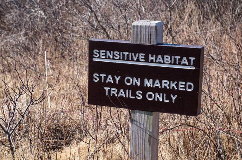
The available North Head trails are closed in the high season, from mid-June to mid-September. They wind along a mowed path through scrub oak and other vegetation, and previously cut over a ridge onto the adjacent Diem parcel. But as hikers approached the boundary earlier this week, they encountered posted signs warning them to go no farther. The trails on the Diem side of the property line were mostly overgrown.

Loop trail connecting the parcels has been blocked by legal dispute.
Loop trail connecting the parcels has been blocked by legal dispute.
“It’s not that there’s no access,” observed Associate Justice Barbara A. Lenk at the Tuesday hearing. “There’s just not preferred access.”
Ms. Tillotson said hikers who want to enjoy both properties would in effect have to walk two separate, unconnected loops, which she asserted would intensify use. Access to the Diem lot also passes over a small section of Taylor property near Lighthouse Road, the lawyers said in written arguments.
“But if that’s what the [Taylor trustees] want, why is that for you to say?” Justice Lenk asked.
“The ‘why’ is it makes no sense…,” responded Ms. Tillotson, especially for a conservation organization that is essentially preserving the land for low-impact activities such as hiking.
Mr. Orloff, the Taylors’ attorney, said an exception would create a “substantial burden” on the Taylors. He added that the land bank knew about the “bright line” restrictions before it bought the Diem parcel, but is now asking the courts to skirt it.
“Is it basically your argument that there is more value in keeping a rule without exceptions that doesn’t require a particularized analysis, case by case, even if at times, such as here, the result is just silly?” asked Justice Lenk.
“Well, I don’t know if the result here is silly because the land bank is arguing that, but they haven’t proved that,” said Mr. Orloff. “Certainly there is a value in having a ‘bright line’ rule.”
Mr. Orloff later said any exception should be done prospectively, otherwise recognizing the land bank’s position would in effect be a “taking.”
“That’s exactly what’s being argued to you here: you should enforce a new easement right to a new parcel to allow the public to walk out onto that parcel,” he said. “But that seems to be exactly the kind of taking that the [the court has] prohibited — or said couldn’t be done without compensation.”
At one point, Chief Justice Ralph D. Gants observed that a loop trail across the two parcels would actually offer some benefit to the Outermost Inn and its owners.
“It seems to be an asset to you to have a nice loop trail for folks after their lovely breakfast on the Vineyard, to take a nice little walk along the water and have it be a loop trail,” he said. “That’s why I’m a little bit perplexed why you’re so upset about this.”
Mr. Orloff and Mr. Hurley, the Taylor trustee, represent the Taylor Trust and are lawyers at Rackemann, Sawyer & Brewster of Boston. Ms. Tillotson of Hemenway & Barnes of Boston and Ronald H. Rappaport of Reynolds, Rappaport, Kaplan & Hackney of Edgartown represent the Martha’s Vineyard Land Bank.
This article has been updated to include a clearer map of the area under discussion.
Comments
It would seem to logical
Eddie Mac NoepeIt would seem to logical folks that the Taylors have the right, within reason , to do what they want with THEIR property.
Here we have another strong arm tactic by a local agency to impose their will in a situation where they have no business or practical standing. Leave it alone Landbank! Or make the Taylor's a financial offer they can’t refuse....you have the resources to do so instead of what amounts to wasting publicly generated funds on legal fees and flumadiddle. Stop strong-arming! Get back to what you are supposed to be doing.........preserving MV land for the public. And, don’t worry about the those hikers too much. There are plenty of other comparable trails on the north end of the island.
LAND ISSUES ARE INHERENTLY
CARLY SIMON TISBURYLAND ISSUES ARE INHERENTLY EMOTIONAL. IT MAY LOOK OR SEEM TO THE OUTSIDE THAT IT'S JUST A SMALL SECTION OF LAND. BUT IT GOES A LOT DEEPER TO IT'S OWNER WHO FEELS IT VISCERALLY. IT'S THE PIECE OF HIS LIFE THAT HE HAS NURTURED AND DEPENDED UPON AND THAT HE WILL LEAVE TO HIS CHILDREN. NO MATTER HOW "REASONABLE" A COURT MAY FIND IT, NO MATTER HOW IT WILL MAKE THINGS EASIER FOR THE LAND BANK AND BE CONVENIENT FOR THOSE WHO DESIRE A CONTIGUOUS, UNINTERRUPTED WALKING PATH, IT IS NOT A REASON ENOUGH TO RE-ARRANGE EASEMENTS. THIS IS A FAMILY TRUST. A FAMILY LEGACY.
I have a great idea since the
Very Annoyed TisburyI have a great idea since the parcels were purchased by land fees which came from the proceeds of land transactions; The Taylor's can have their rights by purchasing the land thus giving back the monies that were expended by public transactions. The Taylor's are holding up the public right to access the lands, I feel they should be penalized.
Seriously? The land bank
William TisburySeriously? The land bank bought the land knowing about the easement why should the trust be at fault here. It's time to consider dismantling the Landbank getting to much like a bully in middle school. Those that are "annoyed" should move back to communist country.
I will say it again, the land
Islander Martha's VineyardI will say it again, the land bank must be stopped. What greed it is to go after someone else's property. This is a sneaky, underhanded land grab. What a misuse of funds from the 2% fee they get from most people buying property-- Boston land attorney Diane Tillotson is exorbitantly expensive! And what an arrogant attitude of entitlement to something that does not belong to the land bank.
Wow. Totally confused. Map
christopher gray chappaquonsettWow. Totally confused. Map not helpful.
Hi Christopher, Thanks for
Editor Vineyard GazetteHi Christopher, Thanks for your feedback. We agreed that the map was confusing, and we have updated the article with a revised map.
This reminds me a little of
Rick Aquinnah loverThis reminds me a little of the beach access situation in Chilmark, the parking rules around Aquinnah, etc. As crowded as the Vineyard is at peak times, it is still a big island. If there wasn't so much private this, private that... the people would be more distributed and it would seem uncrowded everywhere. I've walked and biked by the Outermost Inn hundreds of times, and 99% of the time there was no one else in sight in any direction when I did. So who cares if some hikers want to go admire the cliffs? I understand there are property rights. The part that confuses me is that I always pictured the Outermost Inn owners as the type who would want to tear down fences, not build them. It's depressing.
How much land can Land Bank
New Home Owner. Oak BluffsHow much land can Land Bank have?? Or is necessary? Land bank is another obstacle for owners both previously owned and first time owners-- puting a lean on someone's home for the first 5 years so they can continually verify records. And if a person is found to be lying or falsified paperwork then is fined. I am outraged of theses people and all the hoops that are made for people currently owing and purchasing on the vineyard. I would not be ok with a path on my propert to complete the path. Land bank should of had all the details in order before making a path. What is to say it won't restrict this from reoccurring?
"What is this you call
michael johnson oak bluffs/san francisco"What is this you call property? It cannot be the earth, for the land is our mother, nourishing all her children, beasts, birds, fish and all men. The woods, the streams, everything on it belongs to everybody and is for the use of all. How can one man say it belongs only to him?"
-Massasoit - Wampanoag Grand Sachem
Mikey. Lemme know your two
Eddie Mac NoepeMikey. Lemme know your two street addresses and maybe I will start wandering around your place(s) at
From the article, the map and
Dan Booth Cohen AquinnahFrom the article, the map and the comments, it's very unclear what the argument is about. I made up an answer in my mind, but I'm not convinced it's correct. I doubt those who are stridently arguing one side or the other understand the dispute any better. If anyone does, can you explain it here clearly?
Well, since no one bit on my
Dan Booth Cohen AquinnahWell, since no one bit on my request, here's my guess. The Land Bank owns two side-by-side parcels. Each has an easement that crosses the Taylor property. The proposal is to use a single easement to reach both parcels. The Taylors argue the easement can only be used for one property, not both. The Judge asked, what harm to the Taylors?
Hi Dan, we have updated the
Editor Vineyard GazetteHi Dan, we have updated the article to include a clearer map. We hope that helps.
The new, updated map makes it
Steve Jenkinson Oak BluffsThe new, updated map makes it seem the new loop takes up more of the Taylor's property than the existing access. It looks like a new trail cutting across the front of the Taylor's property, and putting a trailhead on it. I'd be very unhappy with that plan, if I was in their shoes.
Re The judge's comment: "“It
Katherine Scott TisburyRe The judge's comment: "“It seems to be an asset to you to have a nice loop trail for folks after their lovely breakfast on the Vineyard, to take a nice little walk along the water and have it be a loop trail,” he said. “That’s why I’m a little bit perplexed why you’re so upset about this.” - "
Wow, it is pretty disturbing for the judge to express this kind of little personal legal opoinion. My antennae always start vibrating when a party advises his adversary where the adversary's best interests lie. It is a classic manipulative ploy. But why is a judge doing this?
A word of warning to the Land Bank: Plenty of folks are already pissed off at you for various reasons, many of them having to do with draconian measures that affect young home owners and builders (for example, ridiculous interest payments if a young man cannot build his family's house fast enough [while also working full-time] without going into debt; he will find himself in debt to the Land Bank), many of them connected with underhanded and slippery dealings in the process of getting land; some of them connected to the fact that the Land Bank ignores the interests and desires of many residents and town official in its prioritizing of types of acquisitions. We all love Land BAnk properties. But rher are many who do not love the Land Bank and are increasing wondering whether it is worth the trouble. The way the Land BAnk does business is seen as divisive and heavy-handed, also as amounting to taxation without representation. Also, many Land Bank staff and representatives seem to be peculiarly tone-deaf.
My advice to the Land Bank: Be careful. Your political support may not be as solid as you assume. I would definitely back off on the TAylor suit, apologize for the public fracas, pay the Taylor family's legal fees, and give this one a rest.
The map was useless. As someone else commented: Difificult to understand, from the story and clueless map, what this is really about and what land is involved.
Not seeing why they need to
Steve Jenkinson Oak BluffsNot seeing why they need to put the trail through the Taylor's property.
Also, no ancient way or established trail, so, I can't see how the Land Bank can justify this.
I really, really want to see the Land Bank lose, and lose hard. This will set a dangerous precedent on the Island. Next thing you know, they'll be trails through a lot of private properties which will make private property an oxymoron.
good comment, i am 100% with
mike skakelgood comment, i am 100% with you, this isnt the first time and the precedent is almost in place in their minds, this isnt the first shady land bank dealing and i am afraid it wont be the last
If that map is fairly
Steve Jenkinson Oak BluffsIf that map is fairly accurate, that is one long trail going through their property, I can not understand why the trail walkers can't exit the way they came in. But, that would be too easy.
I still don't understand the
Katherine Scott TisburyI still don't understand the map, or the issue, any better.
Who owns "area at issue"?
And what is at issue about the "area"?
I thought this was about a trail.
I see a trail in the "area at issue" and a trail in the "headlands" area.
So, what is the problem?
There must be a better way . . .
the trail that the land bank
informed edgartownthe trail that the land bank wants to connect is the headlands trail to the area of issue. Those two trail loops need to be connected. The trail on the backside of the outermost inn already exists and the map makes it look like the outermost owns all of that property which it doesn't. The land bank owns both of the parcels with the loop trails in them.
So, who owns the other
Katherine Scott TisburySo, who owns the other property? Have they already given permission for the trail that is shown there?
No matter how "commonsense" it appears to the Land Bank's lawyer (and of course "commonsense" here is a self-serving judgment)---nor even how "commonsense" it might look to someone gazing at the map trying to figure things out and seeing where teh two trails are very close to each other---there is not much "commonsense" about property law. It is disturbing when public or private entities make promises and then it turns out to have been in bad faith, and they had their fingers crossed in one way or another. I am thinking, too, of the shenanigans with the new Bowling Alley. They went before the Commission and said one thing, and now it's camel's nose under tent, rinse and repeat. Purchasing a piece of property is also a form of promise---you accept what you bought and don't come back and try to change the deal ex post facto. The Land Bank staff are expert in real estate law, so they knew exactly what they were doing when they purchased thier properties. Were they keeping their fingers crossed behind their backs regarding their real plans? Should we get alook at minutes of meetings, emails, etc.?
Still a lot of strong
Dan Booth Cohen AquinnahStill a lot of strong opinions swirling around facts that aren't clear. My understanding is the Land Bank owns Headlands property and Area at Issue. There are two easements crossing the Taylor property. One goes to Headlands and the other to Area at Issue. The dispute is whether the Land Bank can connect the two trails, so that a hiker can walk in on one easement, walk across both Land Bank trails and exit back on the other easement.
My understanding is that the
Following the discussion ChilmarkMy understanding is that the Land Bank only wants to use one easement to enter and exit both its properties, thereby reducing the pedestrian traffic by one half. The Taylors are currently disputing the Land Bank's desire to join the trails at the Land Bank properties' contiguous boundaries. Instead, the Taylor's position is for walkers to enter one easement, turn around at the end of one loop and exit via that easement; then in order to walk the other Land Bank segment, walkers must enter the property via the other easement, turn around at the end of that parcel's loop, and return via the easement on which they entered. With only one easement rather than two, walkers go in, walk both parcels, and walk out the same way they entered. The same people enter once and exit once; not in/out, and in/out over two separate routes. The Land Bank has closed access to the property from June 15 to September 15, so that the extra foot traffic does not impede the Inn's business.
Add new comment